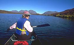
 About 15 miles west of Paxson, the Denali Highway enters the Tangle Lakes region. This land of tundra-covered rolling hills forms the divide between two wild and scenic rivers, the Delta and the Gulkana. A series of long narrow lakes connected by the Tangle River, the area offers a smooth float in the headwaters of the Delta. From the Tangle Lakes Campground at mile 22 from Paxson, boaters and canoeists can paddle through Round, Long and Lower Lakes to the river itself. Fishermen crowd into the area aiming for grayling, plus the occasional lake trout, burbot and whitefish. Rafters can keep going into the Delta for a 29 mile run to the Richardson Highway. The float takes 2 to 3 days with Class I, II and III rapids .
Portaging south from Upper Tangle to Dickey Lake takes floaters into the Gulkana drainage. The headwaters of the Gulkana’s Middle Fork exit Dickey’s southeast tip. Paddlers may be lulled into complacency in the easy floating for the first three miles of the outlet stream. Then the flow plunges into a steep, boulder-strewn canyon with Class III and IV rapids before hitting the Middle Fork. The full trip down the Middle Fork from Tangle Lakes to Sourdough is 76 miles over 6 to 7 days. This trip is an isolated wilderness experience where moose, grizzly and wolves will watch you pass.


Leave a Comment